Document Type : ORIGINAL RESEARCH ARTICLE
Authors
1
Laboratory of Architecture, Urbanism and Transport: habitat, landscape and urban mobility (LAUTr), Institute of Architecture and Urbanism, University of Batna 1, Batna, ALGERIA
2
Laboratory of Study and Modeling of Architectural and Urban Phenomena from Idea to Use (LEMPAU), Institute of Architecture and Urbanism, University of Batna 1, Batna, ALGERIA
Abstract
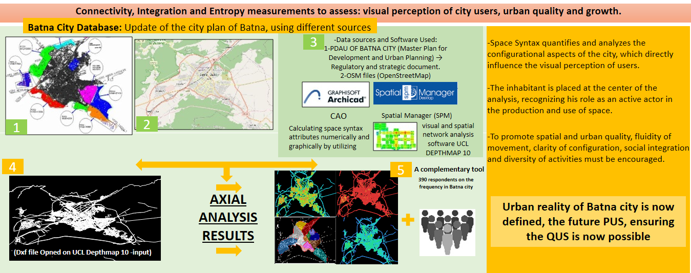
BACKGROUND AND OBJECTIVES: Batna city's road network has evolved due to various factors, particularly residents’ practices and movements, which have shaped the city’s routes and spatial hierarchies. However, the logic of urban production has been unexplored through the prism of user experience. This study aimed to analyze the spatial configuration of the city’s road network, to identify the mechanisms driving the city’s evolution, highlighting the users’ contribution, providing guidelines for future, thoughtful urban planning, and enhancing the quality of urban space by reconciling city users' perception with different approaches to planning.
METHODS: The study applied space syntax Analysis, using depthmap 10 software. It calculated the following parameters: Connectivity, integration, and entropy, and analyzed 25753 axes of Batna’s road network. These measures allowed understanding users’ perception of accessibility, movement, and route choices. This analysis was complemented by a sociological study and field observations. To assess the robustness of the relationship between these parameters, statistical tests were performed, including Pearson and Spearman correlations, as well as a linear regression test analyzed through the ANOVA table, to examine the relationships between two dualities: connectivity/ integration and connectivity/ entropy.
FINDINGS: Connectivity values in Batna city ranged from 0 to 7, with higher values (4-7) found in formal districts. The average integration value was 1.17, peaking at 2.63. Pearson and Spearman confirmed strong correlations between these attributes (p-value less than 0.001), while the ANOVA table from linear regression predicted 14% of the variance in Integration. These values revealed areas with high centrality and accessibility, aligning with the questionnaire responses on urban dynamics and frequency. The analysis also recorded high spatial choice and complexity, revealed by a maximum entropy value of 1.057, observed in more than 25753 spatial units analyzed in this study.
CONCLUSION: The study was distinguished by the inclusive approach, based on the exhaustive analysis of the road structure of Batna city. It highlighted that urban quality and perception, although immaterial and subjective concepts, can be objectified and analyzed rigorously. It advocated for urban planning that is more sensitive to spatial configuration. This study was unique in that it analyzed the entire road network of the city, thus providing a solid basis for testing, in future research, other parameters derived from the Space Syntax method.
Graphical Abstract
Keywords
Subjects
OPEN ACCESS
©2026 The author(s). This article is licensed under a Creative Commons Attribution 4.0 International License, which permits use, sharing, adaptation, distribution and reproduction in any medium or format, as long as you give appropriate credit to the original author(s) and the source, provide a link to the Creative Commons license, and indicate if changes were made. The images or other third-party material in this article are included in the article’s Creative Commons license, unless indicated otherwise in a credit line to the material. If material is not included in the article’s Creative Commons license and your intended use is not permitted by statutory regulation or exceeds the permitted use, you will need to obtain permission directly from the copyright holder. To view a copy of this license, visit:
http://creativecommons.org/licenses/by/4.0/
PUBLISHER NOTE
Tehran Urban Research & Planning Centre (TURPC) takes a neutral position about claims on disputed territories, place names, international boundaries, jurisdiction in published maps, and institutional affiliations. TURPC is committed to retracting a paper after its publication if it becomes apparent that there are serious problems in its content, in terms of research and publication ethics (https://www.ijhcum.net/journal/process?ethics).
CITATION METRICS & CAPTURES
Google Scholar | DOAJ | Scopus | EBSCO | Internet Archive |Twitter |Mendeley
CURRENT PUBLISHER
Tehran Urban Research and Planning Center: Tehran Municipality